Florida’s 1,350-mile coastline borders both the Atlantic Ocean and the Gulf of Mexico — more hurricane exposure than any other US state. Since 1851, Florida has been struck by 120 hurricanes, including 40 major hurricanes (Category 3 or stronger). Hurricane Ian (2022) killed 150 people in Florida and caused $112.9 billion in damage, making it the costliest Florida storm on record. This guide covers Tampa Bay’s overdue surge catastrophe, how to find your county evacuation zone, Florida Keys mandatory evacuation thresholds, and Ian’s specific lessons about canal flooding and late-track shifts.
Major Florida Hurricanes: Historical Data
| Storm | Year | Category at Landfall | Landfall Location | Max Surge | FL Deaths | Damage (2024$) |
|---|---|---|---|---|---|---|
| Hurricane Andrew | 1992 | Cat 5 | Homestead | 16.9 ft | 44 | $57B |
| Hurricane Charley | 2004 | Cat 4 | Charlotte Harbor | 6–7 ft | 10 | $22B |
| Hurricane Wilma | 2005 | Cat 3 | Cape Romano | 5–8 ft | 5 | $31B |
| Hurricane Irma | 2017 | Cat 4 | Cudjoe Key | 15 ft (Keys) | 25 | $77B |
| Hurricane Michael | 2018 | Cat 5 | Mexico Beach | 14 ft | 16 | $28B |
| Hurricane Ian | 2022 | Cat 4 | Cayo Costa | 18–20 ft (Fort Myers) | 150 | $113B |
Tampa Bay: The Most Overdue Major Surge Event in the US
Tampa Bay has not received a direct major hurricane hit since 1921. A Category 4 direct hit could produce 15–20 feet of surge in downtown Tampa — a metro area of 3.2 million people that has never experienced a modern major hurricane.
Tampa Bay’s funnel shape mechanically amplifies storm surge: the bay is wide at its southern entrance and narrows toward downtown Tampa, concentrating any surge that enters from the Gulf. The 1921 Tampa Bay Hurricane — the last major storm to strike the area directly — produced 10.5 feet of surge when Tampa’s population was approximately 51,000. The metro now holds 3.2 million people. Hurricane Ian (2022) took a last-minute track shift south, striking Fort Myers instead of Tampa. Had Ian tracked 50 miles north, Tampa Bay would have received a direct Cat 4 hit.
| Category | Wind Speed | Tampa Bay Direct-Hit Surge | Areas Inundated |
|---|---|---|---|
| Cat 1 | 74–95 mph | 4–6 ft | Immediate waterfront, Zone A |
| Cat 2 | 96–110 mph | 6–10 ft | Zones A–B, coastal roads impassable |
| Cat 3 | 111–129 mph | 10–15 ft | Zones A–C, parts of downtown St. Petersburg |
| Cat 4 | 130–156 mph | 15–20 ft | Zones A–D, downtown Tampa, Ybor City |
| Cat 5 | 157+ mph | 20–25+ ft | Catastrophic — Zones A–E, most of coastal Pinellas County |
Pinellas County (St. Petersburg, Clearwater, Dunedin) is a peninsula within Tampa Bay with only two primary evacuation routes (US-19 and US-92). NOAA modeling identifies Pinellas as the highest surge-risk major urban county in the US. Zone A in Pinellas County must evacuate for any Category 1 or stronger storm threatening a direct Tampa Bay hit.
Florida Evacuation Zones: A Through F
Florida counties use lettered zones (A through E or F) based on storm surge modeling — not wind speed. Zone A is the highest-risk zone; in most counties it corresponds to areas that would flood in a Category 1 storm surge.
| Zone | Surge Risk Level | Evacuation Trigger | Typical Areas |
|---|---|---|---|
| A | Extreme | Any hurricane or strong tropical storm (mobile homes) | Barrier islands, immediate coast, low-lying coastal areas |
| B | High | Category 1+ hurricane | Near-coastal low-lying neighborhoods |
| C | Moderate-high | Category 2+ hurricane | Areas susceptible to moderate surge inundation |
| D | Moderate | Category 3+ hurricane | Inland areas with canal or flood exposure |
| E/F | Lower | Category 4+ or per local orders | Flood risk from rainfall and rising canals |
How to find your zone: Visit your county emergency management website and use the address-lookup tool. Each Florida county publishes an interactive zone map. The Florida Division of Emergency Management statewide lookup is at floridadisaster.org/know-your-zone. Look up your zone before June 1 (hurricane season start) — the site frequently becomes unavailable during active storm evacuations.
Florida Keys: Mandatory Evacuation Lead Times
The Florida Keys present the longest mandatory evacuation lead time in the continental US. The Keys are a chain of low-lying islands connected by US-1 (the Overseas Highway) — a single two-lane evacuation route. The chain requires 24–36 hours to fully clear under contraflow. Monroe County mandatory evacuation triggers:
- Tropical Storm Watch: Tourists, visitors, and recreational vehicles must leave immediately
- Hurricane Watch: Lower Keys mobile/manufactured home residents must evacuate
- Hurricane Warning: All Keys residents must evacuate — no exceptions
A storm moving at 15 mph can close the watch-to-landfall window to 18–24 hours after a Hurricane Watch is issued. Monroe County officials urge Keys residents to leave at Tropical Storm Watch stage — waiting for the Warning means gridlock and potential shelter-in-place during a direct hit on a chain of islands averaging 3–4 feet above sea level. Hurricane Irma (2017) produced 15 feet of surge in the Lower Keys.
East Coast vs. Gulf Coast: Florida’s Two Hurricane Exposures
| Factor | East Coast (Atlantic) | West Coast (Gulf) |
|---|---|---|
| Primary storm tracks | Cape Verde storms, Cape Hatteras recurves | Gulf of Mexico storms, Western Caribbean recurves |
| Rapid intensification risk | Moderate | High — Gulf’s warm shallow water |
| Notable historic strikes | Miami (1926, 1992), Fort Lauderdale, Stuart | Fort Myers (2022), Tampa (1921), Pensacola, Mexico Beach |
| Surge amplification | Open Atlantic exposure; less bay concentration | Tampa Bay and Charlotte Harbor funnel effect |
| Primary evacuation routes | I-95 north toward Orlando/Jacksonville | I-75 north via Alligator Alley to I-4/I-95 |
Ian’s Lessons: What Killed People and What Saved Them
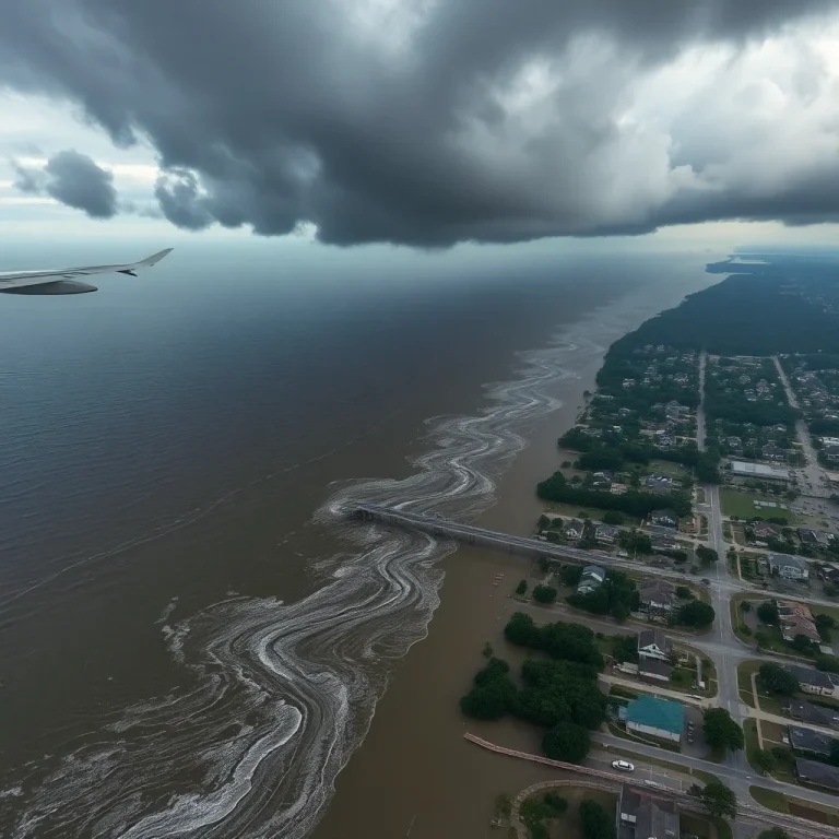
Hurricane Ian (September 28, 2022) was the deadliest Florida hurricane since the 1935 Labor Day Hurricane. NHC and FEMA post-storm analysis identified specific failure patterns:
- Late track shift, accurate surge forecast: Ian’s final track shifted south from early Tampa-area forecasts. Lee County residents who had not evacuated for a Tampa scenario faced 18–20 feet of surge with 6–8 hours of warning. The NOAA surge forecast was accurate for Fort Myers; residents discounted it because Ian appeared to be a Tampa storm.
- Mobile home fatalities: A disproportionate share of Ian deaths occurred in mobile homes. Zone A and B mobile home residents must evacuate for any Hurricane Watch — mobile homes provide no meaningful surge or wind protection above Category 2 intensity.
- Canal flooding extended 12 miles inland: Fort Myers and Cape Coral are laced with canals. Ian’s surge pushed seawater 8–12 miles inland through canal systems, flooding neighborhoods residents believed were protected by distance from the coast. Any home within 1 mile of a canal in Zone A–C requires surge evacuation for a Category 3+ storm.
- Neighbor boat rescues saved lives: In Matlacha, Fort Myers Beach, and Pine Island, private-boat rescues by local residents accounted for the majority of early rescues before FEMA and Coast Guard assets arrived. Households with boats who pre-coordinated with neighbors extracted dozens of stranded residents.
14-Day Supply Requirements for Florida
Post-Ian, Lee County had no power in heavily affected areas for 6–8 weeks. Post-Irma, the Florida Keys had no power in some areas for 3–4 weeks. Florida-specific supply priorities:
- Generator + 20 gallons of stabilized fuel: Air conditioning is a medical necessity in Florida’s August–October heat and humidity. An 8,000-watt generator running AC and a refrigerator consumes approximately 1.5 gallons per hour at 50% load.
- 2 gallons of water per person per day: Florida municipal water systems routinely fail for 7–14 days post-major-storm. Have a gravity filter (Sawyer, Berkey) or water purification tablets as backup beyond stored supply.
- $500 cash in small bills: Electronic payment systems fail with power outages. Post-Ian, cash-only commerce persisted in affected areas for 5–10 days.
- 30-day medication supply: Florida law allows pharmacists to issue emergency refills during a declared emergency — request before the storm arrives. Florida’s large retiree population with daily medication dependencies makes this critical.
Frequently Asked Questions
Pinellas County (St. Petersburg, Clearwater, Dunedin) has the highest documented storm surge risk of any major urban county in the US, according to NOAA modeling. The county is a peninsula within Tampa Bay with two primary evacuation routes (US-19 and US-92). A Category 4 direct hit on Tampa Bay could produce 15–20 feet of surge in downtown St. Petersburg and inundate the majority of Zone A in Pinellas County. Monroe County (Florida Keys) has comparable per-capita surge exposure but lower overall population.
Visit your county emergency management website and use the address-lookup tool. Each Florida county publishes an interactive zone map. The Florida Division of Emergency Management statewide lookup is floridadisaster.org/know-your-zone. Zone designations are based on storm surge modeling — Zone A is the highest risk. Look up your zone before June 1 (hurricane season start), not during an active storm when the site may be overloaded.
Zone A residents should evacuate when a Hurricane Watch is issued — not when the Warning is issued. Evacuation at Watch stage typically means 4–8 hour trips; waiting until Warning means 12–18 hours in gridlock. Mobile home or manufactured home residents in any zone should evacuate for any Hurricane Watch. Zone B and C residents should evacuate for Category 2+ storms directed at their coastline.
A Hurricane Watch means hurricane conditions (sustained winds 74+ mph) are possible within 48 hours. A Hurricane Warning means hurricane conditions are expected within 36 hours. For Zone A residents, the Watch — not the Warning — is the evacuation trigger. By the time a Warning is issued for the Florida coast, evacuation routes are often heavily congested and you may have fewer than 36 hours before tropical-storm-force winds make driving dangerous.
Ian’s track shifted south in the final 24 hours, moving the landfall point from the Tampa Bay area to Fort Myers/Cayo Costa. Lee County residents who had not evacuated — many of whom were watching Tampa storm preparations — faced 18–20 feet of surge with 6–8 hours of final warning. The NOAA surge forecast for Fort Myers was accurate; residents discounted their personal risk because Ian had been framed as a Tampa storm. Late-track shifts are common in the Gulf of Mexico — always evacuate based on surge forecast for your specific zone, not track headlines.
Where to Go Next
General hurricane preparedness — evacuation decision framework, storm surge tables, and action timeline — is in hurricane preparedness: evacuation decision, storm surge, and 14-day supply list. Gulf Coast surge risks including Houston’s Galveston Bay vulnerability and New Orleans’ levee system are in Gulf Coast hurricane preparedness: Texas, Louisiana, Mississippi, and Alabama.